


Retour

Michel GUISSE
User

Length
4.3 km

Max alt
1547 m

Uphill gradient
28 m
Km-Effort
5.9 km

Min alt
1148 m

Downhill gradient
398 m
Boucle
No
Creation date :
2024-01-16 14:32:35.0
Updated on :
2024-01-16 16:03:26.144
1h16
Difficulty : Easy

FREE GPS app for hiking
 SityTrail
IGN / Geographical institutes
SityTrail Plus
The world is yours!
About
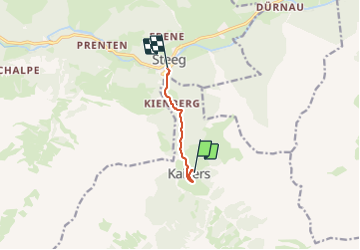
Trail Walking of 4.3 km to be discovered at Tyrol, Bezirk Reutte, Gemeinde Kaisers. This trail is proposed by Michel GUISSE.
Description
Descente vers Steeg
Positioning
Country:
Austria
Region :
Tyrol
Department/Province :
Bezirk Reutte
Municipality :
Gemeinde Kaisers
Location:
Unknown
Start:(Dec)
Start:(UTM)
598530 ; 5229985 (32T) N.
Comments